YORKSHIRE: Mickle Fell (2,585 feet/788 metres)
54° 36′ 48″ N, 2° 18′ 18″ W
The highest point in Yorkshire is a controversial matter. I say controversial, by which I mean it’s something we Yorkshire folk like to moan about. It is true, we like having things to moan about, we’ve got it down to a fine art, but when it comes to our borders and boundaries, we’d rather be in control of our own land. Yorkshire’s borders had been relatively stable since the Kingdom of Jorvik over 1000 years ago, and reached as far North as the River Tees.
For all that time, the highest point was a beautiful summit by the name of Mickle Fell. From where, in my opinion, you will find the most expansive views in England. From the edge of the fell, you can see the Moors, the Dales, Snowdonia, the Lakes, Galloway, the Borders and the Cheviots. It was a fine vantage point for Yorkshire to hold.
In 1974, for reasons to be discussed elsewhere, our county was torn into pieces, and worse our extremities were given charitably to our neighbours. Mickle Fell is no longer in Yorkshire, and stands as the highest point in County Durham. But given “Yorkshire” as a singular entity is an historical concept, to stand at it’s summit, you have to visit Mickle Fell. It’s a bugger to get to, and involves procuring a permit from the Ministry of Defence to wade through miles of barren bog used for army training. However, it is worth it. It may not be IN Yorkshire, but nowhere else has a greater view OF Yorkshire.
If there is one thing we like more in Yorkshire than moaning, it’s waxing lyrical about the great county we are so lucky to live in. So for me, a 12 hour round trip, of which 11 hours are spent shin deep in sheep shit are worth it for an hour to stand high above my county in admiration and awe.
NORTH YORKSHIRE: Whernside (2415 feet/736 metres)
54° 13′ 39″ N, 2° 24′ 12″ W
Let us keep the controversy going, if only because it gives me something to moan about. After Mickle Fell was gifted to County Durham in 1974, Yorkshire was split into North, South and West Yorkshire, with Humberside feeling like an estranged family member. Each county now had it’s own county top, and Whernside in North Yorkshire was the highest of them all at 736 metres. Nothing controversial about that at all.
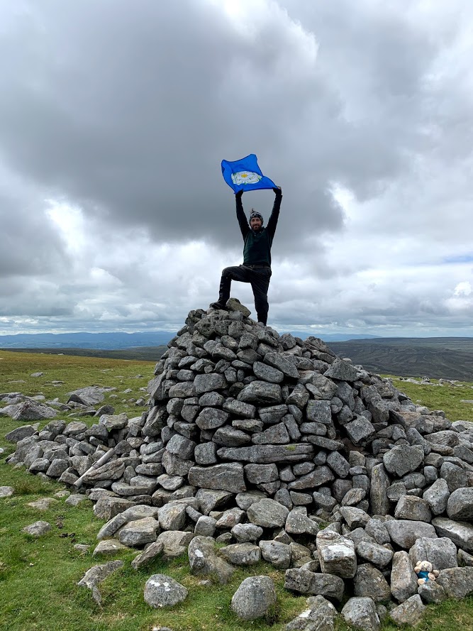
The controversy lies in the thousands of photos online of people just like me, arms aloft atop an Ordnance Survey trig point marked OSBM2982 believing themselves to be the highest person at that moment in all of Yorkshire.
It is likely they have followed the relatively easy bridle path to or from Chapel-le-Dale, possibly on the no less controversial Yorkshire Three Peak Challenge, and indeed will have spent all day in the county of North Yorkshire. However, the moment they step through narrow gap in the cliché dry stone wall, they have entered a whole new realm. The air will taste different, the sky a little greyer, for they will find themselves in Cumbria.
That’s right, the trig point atop Whernside is in Cumbria. It’s not even a particularly high point for Cumbria. There are people on top of Scafell Pike, 242 metres higher looking down upon the current incumbents of Whernside’s trig point, literally looking down upon them for their foolishness.
So do visit Whernside. Be the highest person in Yorkshire, but take your photo the other side of the wall. You might see me there, when I go back to replace my current photo.
EAST YORKSHIRE: Bishop Wilton Wold (807 feet/246 metres)
54° 0′ 6″ N, 0° 45′ 2″ W
Moving swiftly round the compass, we go from North to East Yorkshire, and surely we can’t still be grumbling about summit (forgive the awfully niche pun, specific to county tops in Yorkshire). Actually, I have two things to grumble about…
Historical Yorkshire had stood for nearly a thousand years, and because it was so bloody big, we divided it up into the North, West and East Ridings. In 1974, the government decided to shuffle things about and created the counties of North, West and South Yorkshire. Why? Just why? To create as much confusion as they could, they moulded much of the East Riding into a new county called Humberside. Thankfully in 1996, someone saw sense and the county known as “The East Riding of Yorkshire” was restored. So actually, while I had 22 years to grumble about this, everything’s now all right with the world, so moving quickly on…
The county top of the East Riding of Yorkshire is known as Bishop Wilton Wold or Garrowby Hill. It is a mere 246 metres above sea level, high above many counties, but over half a kilometre lower than Yorkshire’s very highest hill. Still, it is a nice hill with nice views. Indeed, the great Yorkshire artist David Hockney painted the view and “Garrowby Hill” now resides in the Museum of Fine Arts in Boston, Massachusetts. I digress. At the top of this hill lives an Ordnance Survey trig point marked OSBM6296. Around that trig sits a great big bloody fence erected by Yorkshire Water. So if you go to the top of East Yorkshire, you’ll have to make do with the tumulus 30 metres to the East, and like I do, claim it’s higher, despite what the Ordnance Survey tells us.


WEST YORKSHIRE: Black Hill (1,909 feet/582 metres)
53° 32′ 18″ N, 1° 52′ 53″ W
No controversy this time, at least not for us Yorkshire folk. We approve of everything about this Hill. For a start, it’s got a great name. It’s a hill, and it’s black, thick with peaty bog everywhere you look. The Pennine Way starts not too far south of here, and anyone who has walked even a fraction of those famous 268 miles knows that most of the way consists of paving slabs, across flat plateaus of peaty bog.
In fact the Pennine Way goes right across the top of this big black hill, and at its summit passes right by a lovely trig 582 metres above sea level, marking the highest point in West Yorkshire. Admittedly t’other side of those paving slabs is the county of Derbyshire that wants so desperately to be northern, but as and when I choose to trust the Ordnance Survey, the trig point is definitely in West Yorkshire.
The only claims of controversy I hear are from the only slightly more northern folk of Cheshire. For this used to be their county top, in an area of the county known as the “Pan Handle”, for it’s sticky-outy nature compared to the rest of Cheshire. Those pesky 1974 reforms left Black Hill in West Yorkshire, on the border of Derbyshire and close to Greater Manchester, nearly 20 miles away from modern Cheshire.
In fact Cheshire has very few hills at all these days. It’s new county top, known as Shining Tor and 23 metres lower than Black Hill, is right on the Derbyshire border. From it you get excellent views of the rather lovely but low lying county that Cheshire is today. Unlike the view atop Black Hill, of flat expansive peat filled bogs. Still, one to tick off the bucket list (if you have a bucket list long or nerdy enough to include the highest point in West Yorkshire).
SOUTH YORKSHIRE: High Stones (1,798 feet/550 metres)
53° 26′ 43″ N, 1° 43′ 6″ W
Another no nonsense name for the highest point in South Yorkshire. It’s a blink and you’ll miss it kind of place, marked by a pile of stones. Now the pile of stones is not particularly high in itself, to call it a Cairn would be making a mountain out of a mole hill, but it is a pile of stones and it is 550 metres high. So “High Stones” seems a suitable enough name for this county top. Admittedly, it’s not a name you’ll find on many a map. It’s there on my 1:25,000 OL1 Explorer map but not my 1:50,000 110 Landranger map. You’ll find it on Google though, which if we’re honest most of you are using these days anyway.
There’s not much else of interest up the top of Howden Moors, but the view from Howden Edge is spectacular, looking out across the Northern reaches of the Peak District. It grieves me as a Yorkshireman, that so many think of the Peak District as entirely within Derbyshire. Truth be told there are beautiful walks within the National Park’s boundaries to be found in Cheshire, Staffordshire, Yorkshire and even Greater Manchester.
Admittedly, stood at High Stones you’ll find yourself gazing down across the pretty peaks of Derbyshire. In the foreground is the picturesque Derwent Reservoir, on which test runs of the bouncing bomb (made famous by the film “The Dambusters“) were carried out. If memory serves me right, they were dropped from Lancasters, and that’s a county rivalry for another day…

